
The High Arctic
With my 95 year old mother as my companion, the High Arctic was a 3000+ kilometer adventure in the Clipper Adventurer icebreaker from Kugluktuk, Nunuvut, Canada through the northwest passage to Nuut, Greenland.

Map of our trip Through The Northwest Passage. AMAZING....

Kangerlussuatsiaq Fjord. Kangerlussuatsiaq Fjord is 75 km (46.6 miles) long and 700 metres (2,300 feet) deep. The forbidding nature of the fjord’s surroundings preclude settlement for the majority of its length.

The Ilulissat Icefjord, Greenland The Icefjord itself calves form the Sermaq Kujallaq glacier, one of the fastest moving glaciers in the world, with a daily movement of 14,600 meters (40 miles) per year.

Torngat Mountains National Park Reserve About 56% of the range is located in Quebec, 44% is in Labrador and the remainder, les than 1% is located on Killiniq Island in Nunavut.

Grounded Melting Iceberg. On the shores of The Boothia Peninsula, a peninsula in northern Canada, in Nunavut, located between Victoria and Baffin islands.
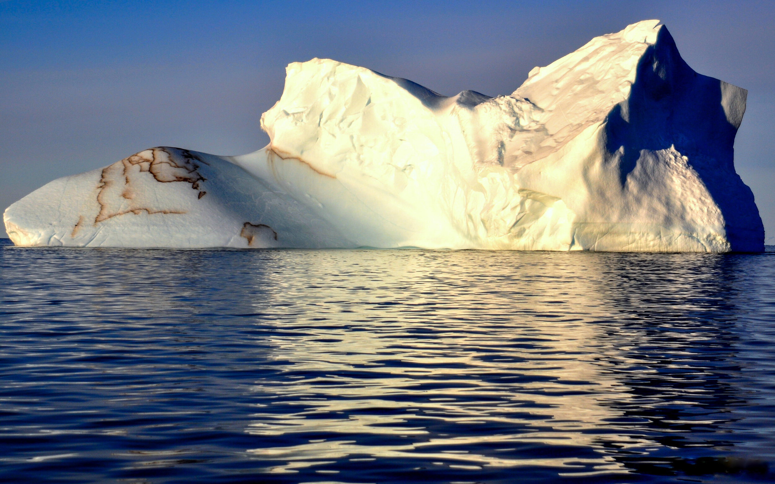
Iceberg in the Ilulissat Icefjord, Greenland. The glacier flows at a rate of 20–35 m (66–115 ft) per day, resulting in around 20 billion tonnes of icebergs calved off and passing out of the fjord every year.

Fort Ross Fort Ross is an uninhabited former trading post in the Qikiqtaaluk Region of Nunavut, Canada. Founded in 1937 it was the last trading post to be established by the Hudson's Bay Company. Situated on the Bellot Strait at the southeastern end of Somerset Island, it was operational for only eleven years as the severe ice conditions rendered it uneconomical and difficult to reach.

Grounded Melting Iceberg on the shore of The Boothia Peninsula, Nunavut

Ilulissat Icefjord A group from The Clipper Adventurer heading for an interesting iceberg off Greenland.

Icebergs at Sunset, Boothia Peninsula, Nunavut.

'Vanilla Sky' Gorgeous sunrise surrounds a grounded melting iceberg. I took this shot from the shoreline on The Boothia Peninsula.

Sunset with the Arctic Light. Taken off Boothia Peninsula, Nunavut. The light IS different in the High Arctic.

Grounded Melting Iceberg. Boothia Peninsula, Nunavut
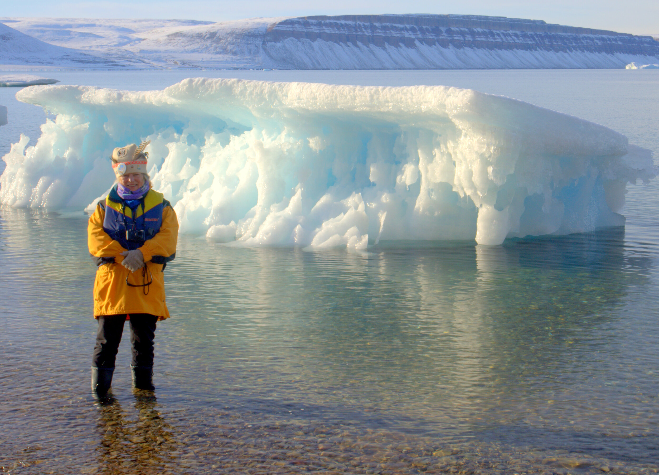
Me, standing in front of a grounded iceberg in Rensselar Bugt (Harbour) in Greenland. Amazing, only 50 km (30 miles) from Canada!

Caswell Tower Caswell Tower on the southern shore of Devon Island in Redstock Bay, Nunavut. It stands 198 meters (650 feet) above sea level and is made up of fossiliferous limestone, shaley limestones and limey shales.

Radstock Bay, Nunavut - Remains of a settlement. The Tule Inuit occupied Radstock Bay more than hour hundred years ago and the former dwellings found here date back to more than 1,000 years.

Kuglugtuk, Nunavut - Inuit Children

Torngat Mountains National Park Reserve The Torngat Mountains cover 30,067 square km (11,609 sq miles), including lowland aareas and extend over 300 km (186 miles) from Cape Chidley in the north to Hebron Fjord in the south. The Torngat Mountains have the highest peaks of eastern, continental Canada. The highest point is Mount Caubvick (also known as Mont D’Iberville) at 1,652 metres (5,520 feet).

Grise Fiord, Nunavut Grise Fiord is located on the south coast of Ellesmere Island overlooking Jones Sound at 76 degrees 24’ N and is Canada’s most northerly community. The community rests at the foot of 600 meter high mountains. It is 1, 544 km from the North Pole. Population of 126 souls 2016. There is an RCMP Outpost there.
Ellesmere Island, Nunavut. We are only 700 km (435 miles) from the North Pole - and no sea ice. Climate Change Proof.

Melting Iceberg, Boothia Peninsula, Nunavut

The Clipper Adventurer moored at sea while we have gone ashore via Zodiac to view and photograph Icebergs.

Zodiacs and Drivers. These great vessels took us ashore and through the ice fields.

The Clipper Adventurer The 118-passenger icebreaker is among the very few vessels in the world specifically constructed for expedition voyages to the remote polar regions. Her ice-strengthened hull permits her to glide easily and safely through ice-strewn waters that are not accessible to conventional cruise vessels.

Karrat Fjord, Greenland The water in the Fjord is an average of 1,000 meters (3,280 feet) deep and the mountains are 610 meters (2,000 feet high), which makes a total of 3 km. Now that is something. Also, the Fjord is 27 – 30 Nautical Miles in length... or 60 km ( 37 miles).

Illulissat Icefjord - It was visually stunning.

Inuit Lad in Kugluktuk, Nunavut

Kangerlussuatsiaq Fjord - Greenland The Fjord takes its source in the tidewater glaciers draining the Maniitsoq Ice Sheet, the fjord flows in a deep canyon through a mountainous, uninhabited region, emptying into The Davis Strait near the settlement of Kangaamiut.

Kangerlussuatisiaq Fjord - Greenland There are actually three separate glaciers.

Nuuk, Greenland Nuuk is the capital of Greenland and is the seat of government for the Sermweaooq municipality. It has a population of 15,469 making it one of the smallest capital cities in the world by population. Nuuk is located about 240 km (150 miles) south of the Arctic Circle.

Nuuk, Greenland The area around Nuuk was first occupied by the pre-Inuit, Paleo-Eskimo people of the Saqqaq culture as far back as 2,200 BC.

Torngat Mountains National Park A saw-tooth skyline of jagged peaks and glacier-carved fjords plunges towards iceberg-dotted indigo waters as polar bears and caribou roam amid some of Earth’s oldest rocks.

Etah, Greenland This valley has been inhabited for over 4,000 years, and we will come across tent rings, a sod hut, a Dorset fox trap and Thule dwellings, among other archaeological finds.

Etah, Greenland Etah, Greenland is a lush valley at the end of a narrow, high-walled fjord. We were able to view a flowing glacier with a large pro-glacial lake at its front.

Karrat Fjord, Greenland Karrat Fjord houses Qeqertarsuaq Island, an island off the north coast of Greenland. The island itself has a mountain called Snaehatten, which measures up to 1750 m tall.

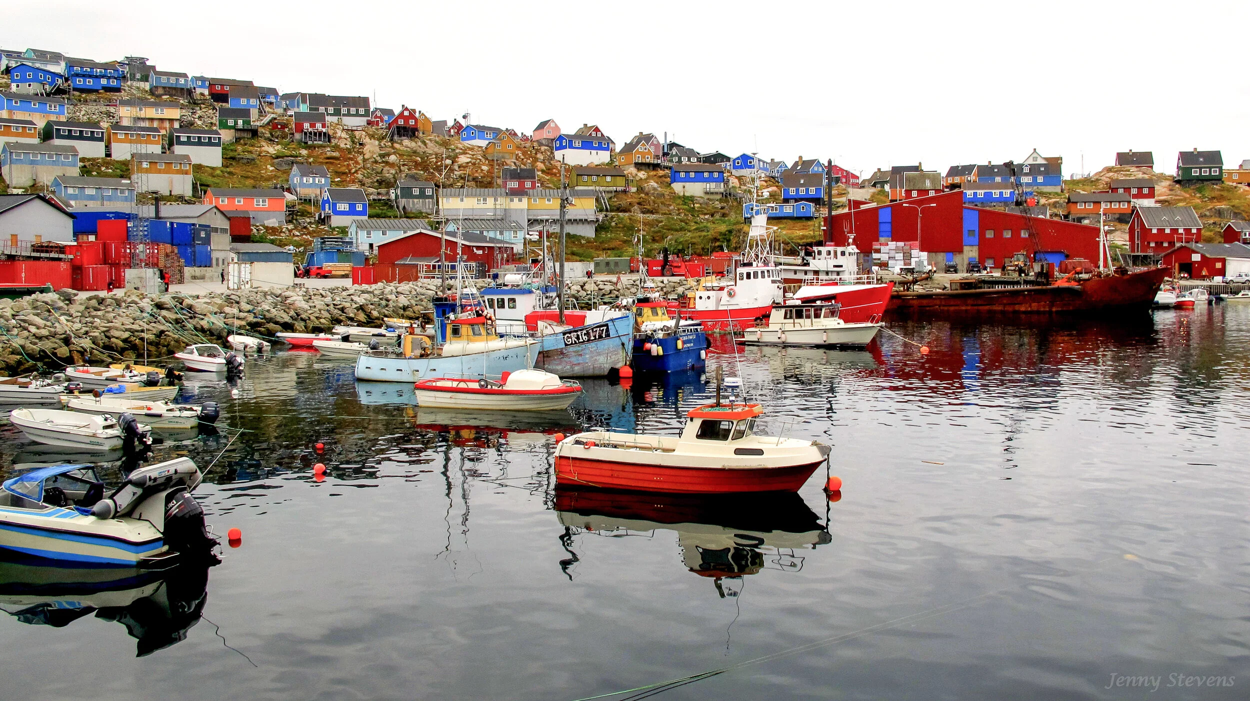
Illulissat Harbour, Greenland Ilulissat is the municipal seat and largest town in western Greenland, located approximately 350 km (220 mi) north of the Arctic Circle. With the population of 4,670 as of 2020, it is the third-largest city in Greenland, after Nuuk and Sisimiut.

Smith Sound - Canada/Greenland Smith Sound is an uninhabited Arctic sea passage between Greenland and Canada's northernmost island, Ellesmere Island. It links Baffin Bay with Kane Basin and forms part of the Nares Strait. On the Greenland side of the sound were the now abandoned settlements of Etah and Annoatok.
Smith Sound - Etah, Greenland Smith Sound, Arctic sea passage between Ellesmere Island, Can. (west), and northwestern Greenland (east). The sound, (48–72 km (30–45 miles) wide, extends northward for 88 km (55 miles) from Baffin Bay to the Kane Basin.

Upernavik, Greenland Upernavik or ‘The Spring Place’ is populated by 1, 100 people, most of whom make their living in the fishing industry. The local women make beautiful beadwork shawls, all different, but all have red. She is selling local wares.

Ilulissat Harbour, Greenland Ilulissat or Jakobshawn is a thriving town founded in 1741 by a trader called Jacob Severin, with a population of 4,000 (and 6,000) sled dogs. Shrimp fishing center.

Pond Inlet, Baffin Island Pond Inlet is a small, predominantly Inuit community in the Qikiqtaaluk Region of Nunavut, Canada, and is located in northern Baffin Island. At the 2016 census the population was 1,617. We could not go ashore in the Zodiacs due to rough seas.

Ilulissat Icefjord - Greenland. Two Greenlader Fishermen fishing the ice cold water without gloves. Amazing !
Upernavik, Greenland Upernavik, town, western Greenland, situated on a small island in Baffin Bay, about 160 km (100 miles) north of Nordost Bay. It was founded by Danes as a whaling and sealing base in 1772. Very colourful town.

Disco Bay, Greenland Mom, Margaret Atwood and Myself - dressed up as Go-Go Girls for the party in Disco Bay - the largest bay in Greenland